First Congressional Map Has Republicans Pleased
On Wednesday, Colorado’s new Congressional Commission staff released a first map of the newly drawn eight congressional districts. It will next be taken around the state by the 12-member Congressional Commission to gather public input.
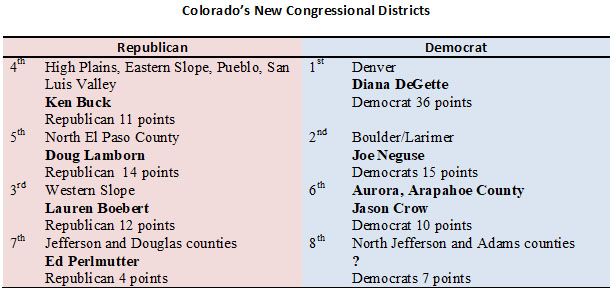
In an interview with KOA’s morning host, April Zesbaugh, she asked about the placement of the newest district in the north Denver metro area. The district location was suggested by the Hispanic community. Its placement is logical given the rapid growth in the area. Democrats, at least preliminarily, appear to support it. This part of the map may not change much and the population is 30 percent Hispanic.
The biggest surprise in the map was the change in the 7th Congressional District, which had been centered in Jefferson and Adams counties and is pushed south to Republican-leaning Douglas County. Incumbent Ed Perlmutter would be in an area he hasn’t represented, and according to staff, leans Republican by 4 points.
Another disappointment for Democrats is the newly designed 3rd district represented by Lauren Boebert. Democrats were hoping by picking up Vail (Eagle County) and Breckenridge (Summit County) partisan registration, which currently leans Republican, would tighten, but it still tilts Republican by 12 points.
So, it appears Colorado, which is now 4 seats to 3 seats Democratic could become 4 and 4. This is producing a lot of buzz in Washington where Democrats only control the House of Representatives by four seats. Could Colorado contribute to the national shift to Republicans?
This, of course, is only the first map in a long process that will have much public input, final census data, and considerable deliberation and Commission voting in the fall. But the process has started and Republicans did well.